Plate Tectonics and Sea Floor Spreading for Science Interactive Notebooks

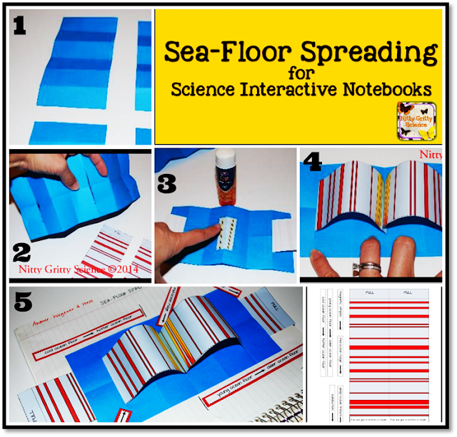
Teaching the concept of sea-floor spreading can be easily modeled using my simple, yet powerful interactive resource for science interactive notebooks.
Earth Science Interactive Notebooks - sea floor spreading
Click image to view product

Using the given template
Plate tectonics earth science sea-floor spreading
click image to view product
and a sheet of colored paper, students will be able to manipulate a model that will allow them to visualize, label, and describe the evidence of Hess's theory of sea-floor spreading which include evidence from molten material, magnetic stripes and drilling samples.  This activity can be found in my Earth Science Interactive Notebook: Plate Tectonic chapter which also features INB activities for:


Plate tectonics sea-floor spreading


All of my science interactive notebook chapters come with the TEACHER INPUT NOTES (as seen above in first picture), detailed instructions for STUDENT OUTPUT ACTIVITIES, MINI-QUIZZES for each concept of the chapter and ANSWER KEYS!

Have fun and enjoy watching your students get excited about their Science Interactive Notebooks!

Celebrating EARTH SCIENCE WEEK

It's EARTH SCIENCE WEEK!  Doesn't that make you just want to sing!?!?
This year the American Geosciences Institute will be organizing Earth Science Week which runs October 11-17 and celebrating the theme "Visualizing Earth Systems".

Everyone can participate in Earth Science Week and most of the work has been done for you.  You can find a list of engaging and educational classroom activities that are based on the Next Generation Science Standards and are marked with the appropriate grade level here.

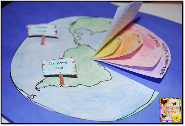
Each day this week I'll be celebrating Earth Week by sharing freebies, special promotions and products with you.  Make sure to follow me on Facebook (www.facebook.com/NittyGrittyScience) to be notified!  My first gift to you, offered for a limited time, will be instructions and printables for making this Earth's Interior interactive activity that is featured in my Earth Science Interactive Notebook: Plate Tectonics.
Interactive Science Notebook
Click picture to download FREEBIE


Did you miss Earth Science Week this year?  Don't worry, the American Geosciences Intstitute love Earth Science so much, that they even made it possible for you to extend the celebration from one week to the whole school year!  Check out this amazing 2015-2016 Activity Calendar which provides, "information about "Visulalizing Earth Systems" activities, career opportunities, happenings, important dates in history, even participation tips, and links to resources on the Web".
If you've organized a special event, celebrate your students' work at school and throughout your community.  I would love it if you wanted to share here with other educators  - please send your photos to nittygrittyscience@gmail.com or share in the comments below on your celebrating!

Interactive 3D Topographic Map YOU CAN BUILD!

science interactive notebooks topography map
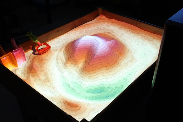
Are you ready to have your students FLIP OUT over topographic maps??  Well, with the help of the researchers at UC Davis and interactive 3D projection technology (and a little sand) you CAN BUILD THIS and blow your students minds!


ucdavis.edu
Using this setup of a Microsoft Kinect, digital projector, and a sandbox, you can now make an interactive topographic map that will show contour lines and elevation in real time and respond to you and your students' actions.

The sandbox in it's natural state gets transformed when the Kinect and the digital projector are turned on and display the graphics from above.

countour lines
ucdavis.edu
contour lines lesson plans
ucdavis.edu
Don't have time to build one yourself or feeling overwhelmed with the technical portion?  Take advantage of those awesome brains coming into your classroom every day! This is a perfect STEM project to get your science students excited about technology and engineering, just like these students from Ithaca's High School FIRST Robotics Team 639. The students built the following Augmented Reality (AR) sandbox in 2013 and have since donated it to a children's museum.
contour lines
ucdavis.edu

ucdavis.edu
Ready to get started?  Go ahead and download these instructions for construction and software setup.  Think your students need some more background on topographic maps and contour lines?  Then check out this chapter from my Earth Science Interactive Notebook series: Mapping Earth's Surface

Want to see more?  Here's a video (ucdavis.edu) showing a virtual dam failure and levee break - simply amazing!!

C'mon, tell me this wouldn't get your students excited about Earth Science.  Have fun with this one!!

Make sure to sign up for my newsletter to get more engaging science lessons and resources that will enhance your curriculum and engage your students throughout the school year.


Related Posts Plugin for WordPress, Blogger...